sci17017 — Announcement
Fifth Data Release for the Legacy Surveys
September 30, 2017
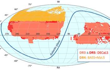
Figure 1. Sky coverage of the equatorial DECaLS footprint (DR5 in red, replacing DR3 in pink) and northern MzLS+BASS footprint DR4 (orange). There is some overlap around declinations of 30 to 34 degrees.
The Fifth Data Release (DR5) of the Legacy Surveys (LS) is now publicly available. As described in the August 2017 issue of Currents, the LS will eventually image nearly one third of the entire sky in preparation for the Dark Energy Spectroscopic Instrument (DESI) survey. This release includes all g-, r- and z-band DECam data and new co-added WISE data within the equatorial portion (lying between declinations of -20 deg and +30 deg) of the DECaLS footprint (Figure 1). The new observations extend the previous coverage in area, spectral coverage and depth. In combination with the previous release (DR4), the Legacy Survey coverage now covers most of the high-Galactic-latitude extragalactic sky visible from the northern hemisphere, and includes over 863 million stars and galaxies.
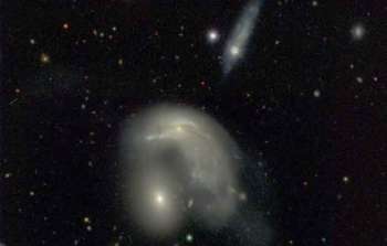
Figure 2. Some of the images from the DR5 picture gallery of galaxy groups. The online gallery links to the location of each group on the Sky Viewer for interactive exploration. The horizontal white bar corresponds to 30 arcseconds on the sky. Hover your mouse over the image to pause the slideshow.
The LS DR5 and DR4 releases include catalogs, image data and an interactive image viewer that enables exploration of the survey. DR5 also includes a picture gallery of galaxy groups (Figure 2), selected to include galaxies with angular diameters larger than 24 arcseconds with neighbors within a 2.5 arcminute distance. These beautiful images illustrate the variety of galaxy shapes and colors with sometimes extreme distortions caused by merging or interacting galaxies.
As with previous data releases, data products are available to the astronomical community and the public via the LS team website, the NOAO Science Archive and FTP server, and through the NOAO Data Lab. The Data Lab hosts databases to query DR4 & DR5 tables among a few various data access methods, and a full list of acknowledgements We encourage user feedback on the data products and welcome everyone to make use of the data. Happy discoveries!
About the Announcement
| Id: |
ID
sci17017
|

